Pearl of Saudi Arabia, Diriyah named Capital of Arab Culture for 2030

The “pearl of Saudi Arabia, Diriyah was named Capital of Arab Culture for 2030 by the Arab League Educational, Cultural and Scientific Organization (ALECSO).
ALESCO said that the selection was due to Diryah local and regional symbolism. The historical city is the birthplace of the first Saudi state, a historical crossroads of pilgrims and traders, and home to one of the kingdom’s most ambitious heritage developments.
It became the second Saudi city to be chosen as the Arab capital of culture, after the capital Riyadh in 2000.
Minister of Culture and Chairman of the National Committee for Education, Culture and Science Prince Badr Bin Abdullah Bin Farhan, said:
“Naming Diriyah as the capital of Arab culture for the year 2030 is the culmination of the march of the capital of the first Saudi state and its historical and civilizational wealth for centuries.”
Curved along the outskirts of Riyadh, and formed on the oasis that spilt from the banks of Wadi Hanifa, Diriyah’s mud-brick walls once housed a thriving desert city that was a powerhouse of culture and commerce. Its At-Turaif district, the area’s citadel-marked primary quarter, was the original seat of power for the kingdom’s Al Saud family. In 1745, the city was named the country’s capital, laying the foundations for what would later become a unified Saudi Arabia.
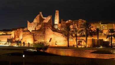
Diriyah fell in late 1818 at the end of the Wahhabi war and was succeeded as the nation’s capital by the nearby settlement of Riyadh. The ruins of At-Turaif were designated a UNESCO Heritage Site in 2010 and the area has since been the subject of a painstaking restoration plan aimed at bringing its historical legacy back to life. While work at Diriyah is still underway, there are ample heritage-rich sites that are open to the public.
Diriyah is located in Wadi Hanifah a short distance northwest of the City of Riyadh. The foundation of the city is traditionally ascribed to the year 1446. The two most important towns of Wadi Hanifah, Diriyah and ‘Uyaynah trace their origin to the 15th century. Diriyah is the name not of a single settlement, but an area of settlement and agriculture — a wadi-based oasis — on either side of an eight-kilometre Stretch of the Wadi Hanifah. The northern limits of the oasis were the villages of ‘Ilb and ‘Awadh, situated on the west bank among the palms. Below these, on the east bank stood the major settlement of Ghasibah. Below Ghasibah were a series of farming settlements extending past the cliff of at-Turaif on the opposite bank. Among these settlements was Bujeiri, where the Sheikh Mohammad Bin Abdul Wahab resided with his family and disciples. The southern side of at-Turaif is bounded by a large tributary, which joins Wadi Hanifah at Nazlat al-Nasiriyah. Beyond this point lies the fertile farming area of Mulaybid, marking the end of the oasis. In its heydays, at the end of the 18th century, beginning of the 19th century, the House of Saud made the naturally defended site of at-Turaif their centre of government. They developed it with imposing palaces and buildings built in a distinctive and confident style. The Imams (the rulers from the House of Saud) also fortified the entire oasis with a wall, with towers at intervals, running along the heights on either side of the wadi.
According to French travellers and scholars who enquired about the city of the Saud in the early 19th century, and collected information from Najdi informants in Cairo, the population of the city was about 13.000 and the settlement counted five main districts/villages. Among these, the principals were at-Turaif, the siege of the government and al-Bujeiri that contained 28 mosques and 30 colleges. At-Turaif quarter became the centre of the “First Saudi State” as it developed during the last half of the 18th century and the first quarter of the 19th century. Increasing revenues allowed the development and expansion across the Wadi Hanifah from the existing Diriyah quarters and the construction of the administrative centre, a treasury and the palaces of the Saudi Princes. From atTuraif, the Emirs and Imams lived and governed an increasingly significant Kingdom that was to eventually include most of the Arabian peninsula and neighbouring Emirates and territories. The Salwa Palace was the first area developed in at-Turaif where, in addition to the administrative buildings and the palaces, certain structures were used for educational purposes by scholars who were supported by the Imams of the Saud Dynasty. The Palace was constructed over some time from 1750 to 1818, and it is considered to be the largest palace in the Najd region.
The social life in the city
Specific and unique characteristics of the city of Diriyah were its religious atmosphere and the continuous presence of petitioners visiting the ruler. At the time of Saud the Great (1803-1814), every day a public study group was conducted in the large open space in front of the Palace so that everyone would have a chance to attend and to hear the exposition of the Holy Qur’an. According to the Najdi 19th century historian Ibn Bishr, at sunrise, the people of Diriyah would sit down to study in the inner place known as al-Mawsim where a large number of people would assemble leaving the centre of the assembly free for Saud and his relatives and the sons of the Sheikh. Every day the ruler attended the study of the Qur’an under the direction of the sons of the Sheikh.
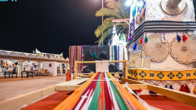
The Imam used the palace to receive its people in the audience hall of the Salwa Palace. He heard their petitions and dispensed hospitality and largesse to his many guests. According to the Western traveller, Burckhardt: “[Saud] resided with all his family in a large mansion built by his father on the declivity of the mountain, a little above the city of Diriyah. All his children, with their families, and all his brothers had their separate apartments in that building… In his house, he kept his treasures and received all those who came on business to Diriyah. There the great Emirs, or chiefs of considerable tribes, were lodged and feasted on their arrival, while people of inferior rank resided with their acquaintances in the town; but if they came on business they might dine or sup at the chief’s house, and bring from it a daily allowance for their horses and camels. It may easily be conceived that the palace was constantly full of guests.”* The fast development of the city and the economic rise of the city brought to Diriyah several artisans, who, jointly with the ruler’s bodyguards and the religious scholars, made the city unique in the region. The largest city market was likely taking place in the bed of the Wadi Hanifah, accessible to merchants and caravans. It was thronged with a cosmopolitan crowd of merchants from Yemen, the Hijaz, Bahrein, Oman, Syria and Egypt. Though Diriyah did not mint coins, various types of coinages were in circulation. From travellers, we know that the market stalls were light and portable.
Apart from the ruler’s bodyguard, a corps of three hundred horsemen in armour at the time of Saud the Great, there was no standing army and the troops had to be levied on a campaign-by-campaign basis. All males between 18 and 60 were liable for service. The number of fighting men increased steadily with the expansion of the Saudi domain reaching some 100,000 or more at its height. Their military superiority derived from their zeal, energy, and obedience to their commanders. Being a citizen militia, the Saudi forces were essentially temporary, disbanding on completion of the campaign. They were very effective raiders, but unsuited to permanent occupation and continuing control of an area. Once a district had been subdued, a Governor and a Qadi (judge) were appointed from Diriyah to ensure adherence to the Reform Movement. Fire-power increased during the First Saudi State, through large scale capture of weapons from its enemies and Imam Saud possessed some 60 cannons.
Defining features of at-Turaif
At-Turaif is located on a low plateau of natural limestone between the large Wadi Hanifah on the north and a series of smaller wadis on the south and east. At its highest point, it is approximately 20 meters above the Wadi Hanifah, somewhat separate and hence clearly identifiable from the natural landforms and the surrounding communities. Yet at-Turaif is also intimately connected to the land, the village development and the agricultural areas that surround it. The physical location and its present relationship in scale with the surrounding development and landforms is a defining feature of the site.
At-Turaif shows consistency of scale throughout the site in the width of streets, of building heights, of architectural details, and the general layout of buildings and traffic patterns and the natural topography, that completes the effect created by the variations of heights, the use of different building materials and surface textures, and the variations in the architectural details. The entire site developed organically, as needs arose and the asymmetrical site footprint reflects both this and the response to the natural topography. Streets developed as needed for circulation, for defensive purposes and in response to social relationships. Site lines were important but do not exist in any recognizable grid pattern. The resulting asymmetry is one of the most important characteristics of the site. North-south streets are typically more regular and more consistent in their directional orientation than are the transverse street, or those generally extending along an east-west axis. In some areas of the site, the streets appear to define the orientation and general massing of the structures. In other cases, the structures appear to define where the streets are located. There is some evidence of streets that exist now and are not part of the original street pattern. However, this seems to be the exception rather than the rule and the general character and pattern of the streets that exist today are probably very similar to the character and pattern that existed in the early 19th century. The colours and textures of the earthen architecture are a unifying factor throughout the site. While there may have been greater variations in earlier periods as some of the structures may have been completed with different renderings, there is little evidence of that presently, except for some of the buildings that were adaptively reused in the 20th century and some historic interiors. Existing differences are not visually disruptive, but rather add a level of complexity that enhances this physical characteristic.
The existing plasters are all of mud, but they too vary in different areas of the site and are also probably associated with different buildings periods. The two main mud plaster types are smooth plaster that was applied in lifts from the base of the wall to the top and plaster with more aggregate and appears to have been applied in horizontal bands. Some of the present banding effects are based on the weathering of the plaster, but other more radically banded plaster appears to be conscious.
There are distinct variations and differences in the type of building materials and building systems used in at-Turaif within the general category of earth architecture, some of which can probably be identified with a specific temporal period. In addition to the earth architecture represented by several types of mud brick construction and what appears to be monolithic earth construction, there is also masonry construction of several types that utilize an extensive amount of earth mortar in the building systems. In fact, the distinction between earth architecture and stone masonry is often blurred in the actual execution on site. The use of mud brick with stone foundations and mud plaster are important character-defining features of the present structures and site, although there are variations in the specific construction methods and materials. The size and quality of the stone foundations of several of the palaces are different from the ones of the smaller houses and the later buildings. The use of stone is much more frequent on the western part of the site; there the combination of a rubble stone masonry for the lower portions with a mud-brick wall for the upper portions is the predominant method used. Stonemasonry walls are not found extensively in the Salwa Palace complex but are found on the fringes of the main urban core. Ruins of large houses, small houses, defensive features, buildings that appear to be for the general support of the community at large, structures associated with the site infrastructure, religious buildings, both in ruins and partially restored or reconstructed, reconstructed examples of several building types, and the archaeological ruins are extensive and are all part of the overall texture and fabric of the built environment.
Architectural details, from the earliest structures in at-Turaif to the latest structures from the mid 20th century, contribute to the character of the site. The most significant character-defining details from the earlier periods are the large shaped foundation stones, battered mud-brick walls, mud plaster applied in lifts that have eroded to reveal the lifts, wall penetrations of ventilators in specific, decorative patterns. These decorative patterns formed by the ventilators changed over time and in the larger Palaces became more complex. Stone columns were important architectural details, only a few of which survive in place. Simple geometric paintings exist on a few surviving wood lintels and beams, a practice continued in the 20th century as well, although the later paintings appear to use more colours. Character-defining details of the 20th-century adaptations are more windows and doors, the absence of ventilators, metal doors and door frames, the adaptation and incorporation of earlier building fabric, surface renderings of plaster on interior and some exterior wall surfaces. Column drums of limestone were incorporated as foundations stones but were also used as capitals in the rehabilitated structures. The installation of fixtures for modern conveniences, such as the metal brackets attached to buildings for the attachment of electrical power lines, remain as evidence of the use of the site in the 20th century.
The neighbourhoods of al-Bujeiri and al-Ghasibah
Little remains of the other historic neighbourhoods that composed the city of Diriyah. Short sections of the stone-built wall surrounding al-Ghasibah are still preserved on its northern side, but this quarter, probably the oldest of the entire site, lays in ruin since its destruction in 1818 and is now but an extensive ruin field. Al-Ghasibah is owned by SCTA and is surrounded by a metal fence protecting it from encroachment. The little mud-brick mosque of Shaikh Mohammad Bin Abdul Wahab in al-Bujeiri is the only ancient vestiges still visible on the opposite bank of the wadi in front of at-Turaif. Bujeiri was the centre of the Shaikh’s reforming mission where he lived with his large family. This building, carefully preserved, has a single characteristic square Najdi minaret. Few mud-brick buildings likely more recent, complete the historic environment of the neighbourhood now dominated by the large new mosque built in the 1990s.
The palaces of the House of Saud
1- The Salwa Palace is considered to be the largest palace in the Najd region. The footprint of the palace covers approximately 10,000 square meters and consists of seven main blocks or units. It is assumed that the earliest structure on the atTuraif site was constructed around 1750, but there has been a suggestion that the earliest construction may be as early as the late 17th century and then rebuilt by Imam Muhammad Bin Saud in the middle of the 18th century. The complex, partly surrounded by a separate wall, formed the residence and the seat of government of Saud the Great. It included palaces, a large audience hall, a mosque and a well. Directly adjacent to it stood the Bayt al-Mal (Treasury).
2- Ibrahim Bin Saud Palace is located southwest of the main Salwa palace complex and immediately adjacent to the Fahad Bin Saud Palace on the west. It was apparently constructed prior to the Fahad Palace and is a two-story open court structure, with exterior dimensions of approximately 14 x 13 meters. The interior was also adapted in the 20th century, but many of the structural walls remain. The exterior north side has the remains of a defensive feature above the main entranceway. Ibrahim Bin Saud was the fifth son of Saud the Great; he was killed during the siege in 1818.
3- The Fahad Palace is often considered as the north unit of the Abdallah Bin Saud Palace. It too is rather compact and is the smallest of any of the major palaces. Fahad Bin Saud Bin Abdulaziz was the son of Imam Saud Bin Abdulaziz; he was taken to Egypt after the fall of at-Turaif in 1818.
4-The Sabala Moudhi (endowment of Moudhi) was constructed by the wife of Muhammad Ibn Saud, who died in 1765, probably as a residence and then converted to a sabala for travellers. It is in very poor condition but contains the only remaining example of a full two-story portico that surrounded a small courtyard in at-Turaif. It is immediately adjacent to the Moudhi Mosque, which has been restored, or probably more accurately, rehabilitated as a Mosque by the 20th-century inhabitants. There is evidence of the original relationship of the mosque and the sabala or residence but a more comprehensive and thorough research and documentation is needed.